

A survey plan is a map. A map is only useful if the terrain hasn’t moved since someone drew it. Lagos land has a habit of moving, at least on paper, while a seller insists the plan in his hand is gospel. Two different families can hold two different survey plans for the same plot, each one looking perfectly official, each one pointing at ground that overlaps the other’s claim. That’s the problem this article solves.
Why Lagos law makes survey plan verification mandatory before registration
Lagos will not let a sublease or mortgage near the register without a survey plan attached. The registrar is barred from registering any assignment or sublease unless the land has already been surveyed, which in practice means the survey plan travels with every title document as supporting evidence, not an optional add-on.
That single rule explains why a buyer who skips verification isn’t just taking a risk on paper accuracy. They’re taking a risk the law itself treats as non-negotiable at the registration counter.
Here’s where the trade-off bites. Getting a survey plan is not instant and not free, and Lagos has made the stakes of delay explicit. Where a sublease or mortgage isn’t presented for registration within six months, the transaction attracts an extra ₦500 per month on top of the baseline registration fee, for as long as the delay continues, under the Lagos State Lands Registration Law 2015. That penalty is modest in naira terms. The real cost is what it signals: Lagos treats a survey plan as time-sensitive paperwork, not a formality you get around to eventually.
For a buyer, the practical reading is this. If a seller hands over documents that reference a survey plan but can’t produce the plan itself, or offers a plan with no clear link to any registered instrument, that’s not a paperwork gap to smooth over later. It’s a sign the transaction may never clear registration at all, penalty or no penalty.

Lagos has not always had one tidy system for this. Before the 2015 law, the state ran under three separate statutes covering different parts of Lagos, each with its own registration format, and nobody could fully explain why one area registered titles while another registered instruments, according to research published in the Journal of Commercial and Property Law. The 2015 law was meant to end that fragmentation by declaring itself the only registration statute now in force in the state.
What that history means for a buyer today: don’t assume an older survey plan or title document was processed under the rules you’d expect from a 2026 transaction. A plan lodged decades ago, under a different statute, in a different part of Lagos, may carry a format that looks unfamiliar to a lawyer checking it against today’s registration standards. That’s not automatically fraud. But it is a reason to have a lawyer trace which statute governed the original registration, rather than assuming consistency across the state.
The judgement call here is simple to state and easy to skip under pressure: never let a seller’s urgency substitute for the registrar’s requirement.
What document details must reconcile between the survey plan and land titles
A survey plan with beautiful coordinates and a title document with a different plot number are not two halves of one file. They’re a warning.
Verifying a Certificate of Occupancy means checking that several specific details on the document actually agree with each other and with the person standing in front of you.
That last detail is the hinge. A survey plan number on the C of O that doesn’t match the survey plan the seller hands over means the title document is describing a different parcel than the one being sold. It happens more than buyers expect, sometimes through carelessness, sometimes because the plan being shown was never the one used to perfect the title in the first place.
What changes for a buyer once this is understood? A seller producing a genuine C of O for a different plot is still a seller producing a fake transaction for the plot actually on offer.
Digital tools have made part of this check faster. Landcheckk offers instant digital verification of Certificates of Occupancy, Governor’s Consent, Excision Gazette status, and survey status for plots across Lagos State, letting a buyer cross-check a document’s claimed status against records before money changes hands. That kind of check belongs early, before a site visit, before a deposit, while the transaction can still be walked away from cheaply.
It would be a mistake to treat a clean digital status check as the finish line, though. Status verification confirms a document exists and shows a particular status in the system. It doesn’t confirm the seller named on it is the person selling to you, and it doesn’t confirm the physical boundaries on the ground match what’s written.
Those are separate checks, and skipping either one because the other came back clean is how disputes start. Buyers who want the fuller picture of what a sound Lagos title check involves can look at a detailed walkthrough of verifying land titles before purchase.
| Detail to check | Where it appears | What a mismatch suggests |
|---|---|---|
| Instrument number | C of O / Governor’s Consent | Document may not be genuinely registered |
| Registered owner name | C of O, matched against seller | Seller may not hold valid title |
| Plot, block, scheme, LGA | Title document and survey plan | Documents may describe different parcels |
| Survey plan number | Referenced on the C of O | Title may be unconnected to the plan shown |
| Date of issue / unexpired term | C of O | Lease term may be shorter than represented |
A table like that is not a substitute for a lawyer’s search at the Lands Registry. It’s a checklist for what the lawyer’s search needs to confirm.
Verify physical beacon coordinates on the ground before closing
Paper can say anything. The ground can’t.
A buyer needs a surveyor registered with the Surveyors Council of Nigeria (SURCON) to physically confirm that the beacon coordinates written on the survey plan match the staked boundaries of the actual property, and for high-value areas such as Ikoyi, Victoria Island, Lekki Phase 1 or Ikeja GRA, this is described as a mandatory step rather than an optional one, per cabans.ng. The implication is blunt: a survey plan that was never checked against the physical beacons on site is a document, not a guarantee.
Beacon re-establishment matters because beacons move, or get moved, or were never placed accurately in the first place. Without that lodgment check, a buyer is trusting a plan that may never have been formally deposited with the state at all.
A physical site inspection exists for one purpose here: confirming that the coordinate data on the plan lines up, point for point, with the boundaries actually marked on the ground, which closes off the specific fraud of a plan describing land that overlaps or sits somewhere entirely different, as explained in guidance on checking survey plans online. This is the check that catches the plot sold twice, or the plot whose boundaries quietly crept onto a neighbour’s land, or the parcel that was never where the seller pointed.

What should a buyer prioritise if time or budget is tight? The beacon verification comes before the paperwork polish. A flawless-looking title document attached to land whose beacons don’t match on the ground is worth less than a slightly untidy title on land that physically checks out, because the physical mismatch is the one that ends in demolition notices or a rival claimant showing up with his own plan for the same spot. Document review and ground verification are not sequential nice-to-haves; they’re two separate failure points, and either one alone can sink a purchase.
It’s worth saying plainly: this step costs money and time most buyers would rather skip. It is also the one check that most directly protects against paying for land that turns out to belong, on the ground, to someone else or to the state.
Where land disputes over conflicting claims actually end up
Survey verification exists because Lagos has a long, documented history of overlapping land claims reaching the courts, not because lawyers enjoy paperwork. One Lagos Court of Appeal matter involved a public notice from a traditional ruling family asking landowners in Ajah to submit their documents for verification, following a Supreme Court judgment affirming terms of settlement in an earlier land dispute.
Before that verification exercise concluded, the family in question sold two plots belonging to someone else to a different buyer entirely, who then built on land he didn’t actually hold title to, according to the reported judgment in Otunba Hakeem Sobande v Barrister Andy Igboekwe.
That sequence is exactly the fear this reader carries: a sale completed while a competing claim was still unresolved. The fix isn’t complicated to state. A seller’s confidence is not evidence. A cleared court record and a lodged, re-established survey plan are.
Regulated costs of survey plans across Lagos zones
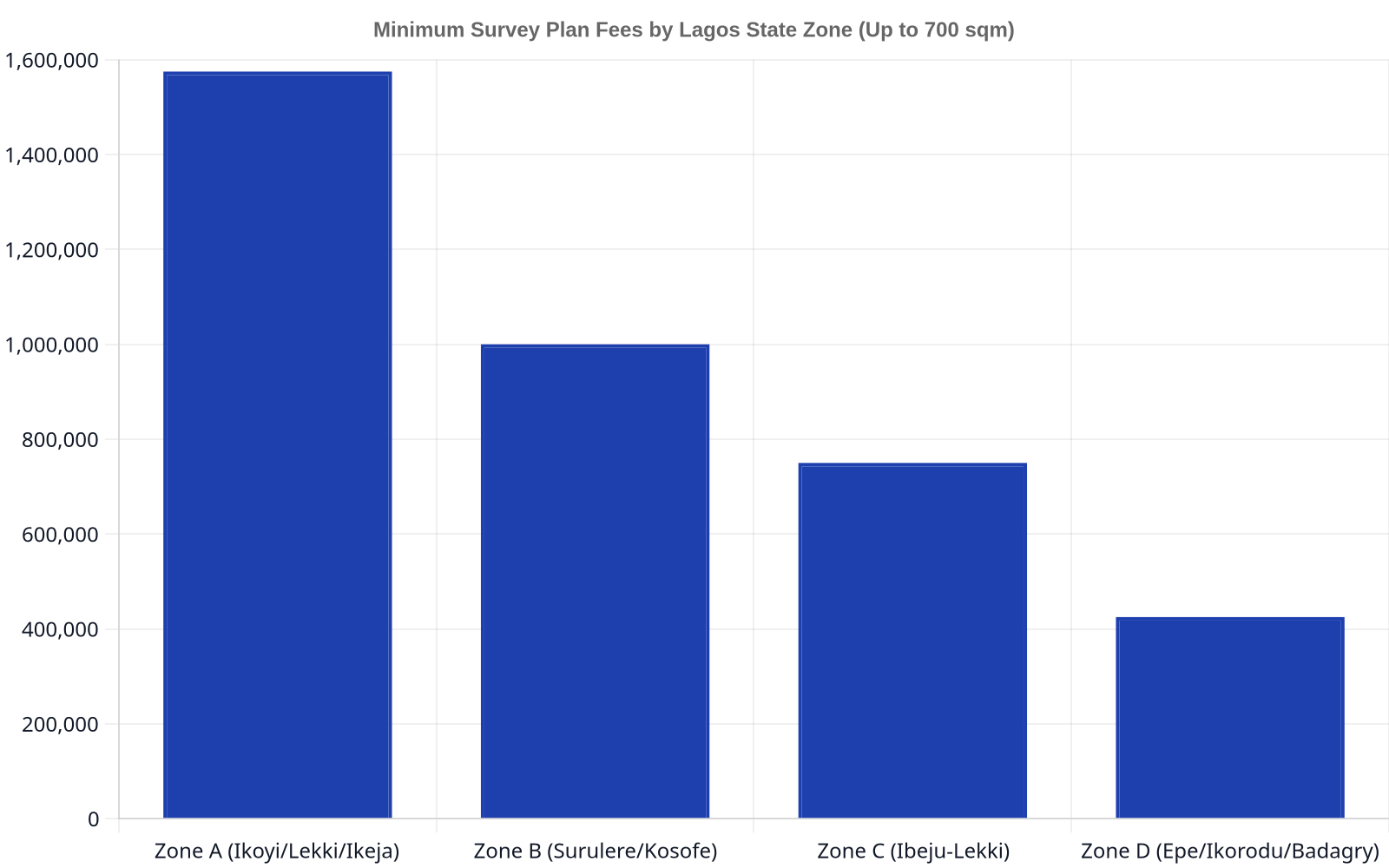
Lagos splits survey plan costs into four geographic zones, each carrying its own regulated minimum fee for a residential plot up to 700 square metres under the Cadastral Survey Practice Policy of the Lagos State Branch of the Nigerian Institution of Surveyors.
Commercial titles carry double the residential minimum in every zone.
Part of that fee isn’t the surveyor’s own charge at all. The survey fee in Lagos includes a mandatory payment to government for an approved survey plan, with the remainder covering the site work and office processing the surveyor actually performs, per the same source’s cost breakdown. A buyer comparing two surveyor quotes that differ wildly should ask which portion is the statutory government payment and which is the surveyor’s own margin, because the government portion isn’t negotiable.
What this means practically: a quote well below the zone minimum for the plot’s location is a reason for suspicion, not celebration. A plan produced for less than the regulated floor may have skipped the government payment altogether, which risks producing a document that was never properly lodged.
Frequently Asked Questions
What makes a Lagos survey plan legally valid?
A plan missing SURCON licensing or never lodged with the Surveyor-General’s office falls short of that standard, whatever it looks like on paper.
Does a government land acquisition override a survey plan and title?
Land the Lagos State Government has acquired for public use carries risk regardless of how clean the paperwork looks. The Lagos State House of Assembly has required the Lands Bureau to clarify allocations and approved compensation for communities whose land was acquired for public purposes, with directions to issue excision or allocation letters and Certificates of Occupancy to affected communities, according to the Assembly’s own report. Before relying on any survey plan or title, confirm the parcel isn’t sitting inside a government acquisition area, since that status can unwind a sale no matter how accurate the beacons are.
A survey plan can be beautifully drawn, properly licensed, and still describe land you should never buy, if nobody has checked it against the title, the ground, and the government’s own acquisition records at the same time. That’s not a one-afternoon errand; it’s a sequence of checks that each catch a different kind of fraud. We handle real estate due diligence for buyers and developers across Lagos, from title searches at the Lands Registry through to coordinating with licensed surveyors on ground verification. Get in touch with our property team before you sign anything.
This article is general information only and is not legal advice. It does not take account of your particular circumstances. You should obtain advice specific to your situation before acting.
About the author

Sandra Adeniran
Principal Partner
Adebola Adeniran is the Founding Partner of Ardnas Legal Practitioners. She is a dynamic and forward-thinking lawyer with a passion for providing innovative legal solutions to businesses and individuals. Adebola combines deep legal expertise with a practical, business-oriented approach, ensuring that clients receive advice that is both strategic and actionable.